Introduction
Active Location and Emergency Reporting Tool (A.L.E.R.T) seeks to reduce the response time of emergency responders by providing more accurate location information. Emergency Authorities (EA) in the UK such as the Police, Fire Department and Ambulance Services respond to an average of 85,000 calls per day. In many situations, the time taken to reach the scene can make the difference between life and death.
According to the Global Standard for Mobile communication (GSM), a cell is the geographical area that a Base Transceiver Stations (BTS) transmission covers and each cell has a unique Cell-ID that identifies it. By identifying which cell tower the phone is connected to, the physical location of the phone can be deduced to be within a radius of the BTS.
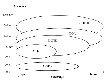
Cell-ID-based location is simple and inexpensive but inaccurate because of several factors. Firstly, the physical size of a cell varies significantly, ranging from tens of meters to several kilometers in radius. Hence, the location is only deduced to be within a certain radius of the BTS. Generally, in the downtown part of a city with many BTS, Cell-ID tends to be more accurate than in rural areas where one BTS covers a large geographical area. However, the location of the caller is still inaccurate. Also, location from Cell-ID is based on the assumption that the mobile phone is connected to the nearest BTS, which is not always the case. In situations where the mobile phone is not connected to the nearest BTS, the accuracy of the location information is seriously affected.
In the diagram on the right the accuracy of Cell-ID is illustrated. As can be seen it compares badly against other location methods. Although very accurate location information is not needed when redirecting the call to the relevant EA, it can help the EA reduce their response time as responders will know exactly where to go. Hence, we propose using A-GPS to relay more accurate location information during an emergency call.