Proposed Solution
A.L.E.R.T is based on similar solutions that have been implemented in other countries such as Japan, South Korea and the United States of America (USA). However, it can be adapted to the unique circumstances in the United Kingdom.
Press the "Emergency Call" button to start the animation.
Two approaches can be used to relay more accurate location information to EAs; namely, the control plane or user plane. In the control plane solution, the network operator (e.g. O2, Vodafone, and Orange in the UK) would need to upgrade their current signaling equipment to implement the SS7 protocol defined by the International Telecommunication Union Telecommunication Standardization Sector (ITU-T). While the control plane solution is reliable, secure, and backward compatible with older 2G mobile phones, it poses significant cost and complexity for network operators to interface with the different technology standards (e.g., 2G GSM, 3G UTMS, and 3G CDMA).
The core technology involved in A.L.E.R.T is GPS, which is a satellite-based navigation system operated by the US Defence Department and made available for civilian use since the 1980s. GPS signals are constantly transmitted to Earth by navigation satellites. The civilian GPS signal, dubbed L1 frequency, operates at 1575.42 MHz. Each GPS signal contains information regarding the satellite from which the signal came from, exact orbital position and current time and date of the satellite (ephemeris data), and orbital information about the other satellites in the system as well (almanac data). A GPS receiver calculates the distance between itself and the satellite by observing the time difference between the signals transmission from the satellite and its reception. With distance information from at least three satellites, a GPS receiver can calculate its two-dimensional location in terms of latitude and longitude by triangulation. Click here for more information on GPS.
The solution used in other countries is implemented on the control plane and emergency authorities have expressed their preference for the control plane approach through location-based services (LBS) rather than the user plane approach. However, mobile operators in the UK are reluctant to provide this platform as it involves a large capital investment of at least £9m per operator. This makes the control plane an unfeasible solution for the near future. A solution using third party software is still plausible despite it being theoretically less reliable.
The User plane solution avoids costly and complex modifications to network signalling equipment by using a data connection to send the location information to a server. This involves installing third-party software onto the mobile phone which will control the formatting and uploading of the data. The disadvantages of this solution are that it is incompatible with older mobile phones and require a data connection.
Our proposed solution to incorporate GPS location accuracy in emergency response is a mobile application (app) designed specifically for emergencies and freely downloadable from app stores for most platforms. There is a market for A.L.E.R.T to be implemented as an app in smartphones because of the high penetration of smartphones (50.3%) in the UK. As this number has been increasing over the years from 11% in 2010 to 27% in 2011 and 39% in 2012, the potential for this solution is likely to become more viable in the near future.
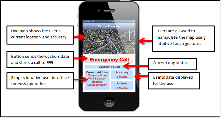
Above shows a screenshot of the iPhone application that demonstrates our proposed solution. When the A.L.E.R.T app is started, it immediately invokes the iPhone location manager which starts the smartphone's A-GPS hardware and returns the user's location. The inbuilt Apple maps kit is used to display the location, which is continually updated and shows the area of accuracy. A reverse geocoding request to Google's map servers translate the longitude and latitude data into a street address which is also displayed in the app. The map and data fields are updated whenever the user moves more than 5 metres.
When the "Emergency Call" button is pressed, the app sends the location data to a remote webserver using a PHP: Hypertext Pre-processor (PHP) post method. This submits the data to the server to be stored in a database containing phone numbers and their latest locations. The database used for the demonstrator was a simple text file, and the data was submitted in less than a second. Simultaneously, the smartphone will call the local emergency services.
In the actual system, other important factors such as security, scalability, and reliability will have to be more thoroughly considered. An actual system will require a suitably-secured SQL data server to protect privacy and manage the large volume of data. Also, instead of a PHP post, a more robust uploading protocol can be established to ensure reliability and prevent abuse of the system.
When fully integrated, the emergency dispatcher will be able to retrieve the user's location through the EISEC system as the call is in progress. The GPS location information can then be passed to the emergency responder through the current dispatch system.